Redpossum
Registered
- Joined
- Mar 20, 2014
- Messages
- 2,786
- Likes
- 2,685
To be clear, I'm neither a climate change denier nor an eco-warrior. My views lie somewhere in the middle. Moreover, this thread isn't about any of that; I'm not going to talk about effects or who's to blame or any of that political tripe. I just want to share with you all some of what I just learned about methane emissions in Argentina, and ask if some of you can help me figure out what's happening.
Where it's coming from, in the literal sense of geo-location, is fairly easy. What it's coming from is another matter, and that's the part I'm hoping for some help with.
So, it began with this YT video -
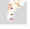
At 12:32 there is an intriguing map of methane emissions worldwide. To see Argentina in more detail, I used screen snip.

Yes, its grainy and pixellated, because I zoomed in quite a bit. For comparison, I offer this map-
You may want to r-click on that link and choose "open in new tab"
So, the topmost of the 4 purple splotches, (the dark purple represents the highest levels of methane emissions), is clearly CABA; the notch in the coast is unmistakable. The southernmost one is odd. It seems to be the Rio Gallegos - Punta Arenas area. Let me know what you think. The one just north of that is centered on Commodoro Rivadavia. There's no mistaking that round bay and the protruding "shelf" just south of it.
The last one is tricky. You can see a small orange dot on the coast that is clearly Bahia Blanca, straight SW of CABA, and the last purple splotch is straight east of there. It's large and diffuse, and seems to me centered around the 4-corners area just north of Neuquén.
OK, now the part with which I'm asking for your help. What happens in those places? CABA is easy to explain. I suspect that the two in the middle are related to petroleum extraction. But the southern one puzzles me entirely. What do you think?
Please, please, please can we avoid politics in this thread? Can we not have the usual rants against Peronism, indictments of Argentina's inadequacy, etc etc? I'd just like to talk about what you think are the sources of these emissions. Please.
Where it's coming from, in the literal sense of geo-location, is fairly easy. What it's coming from is another matter, and that's the part I'm hoping for some help with.
So, it began with this YT video -

Yes, its grainy and pixellated, because I zoomed in quite a bit. For comparison, I offer this map-
You may want to r-click on that link and choose "open in new tab"
So, the topmost of the 4 purple splotches, (the dark purple represents the highest levels of methane emissions), is clearly CABA; the notch in the coast is unmistakable. The southernmost one is odd. It seems to be the Rio Gallegos - Punta Arenas area. Let me know what you think. The one just north of that is centered on Commodoro Rivadavia. There's no mistaking that round bay and the protruding "shelf" just south of it.
The last one is tricky. You can see a small orange dot on the coast that is clearly Bahia Blanca, straight SW of CABA, and the last purple splotch is straight east of there. It's large and diffuse, and seems to me centered around the 4-corners area just north of Neuquén.
OK, now the part with which I'm asking for your help. What happens in those places? CABA is easy to explain. I suspect that the two in the middle are related to petroleum extraction. But the southern one puzzles me entirely. What do you think?
Please, please, please can we avoid politics in this thread? Can we not have the usual rants against Peronism, indictments of Argentina's inadequacy, etc etc? I'd just like to talk about what you think are the sources of these emissions. Please.
