hankscott
Registered
- Joined
- Jul 20, 2020
- Messages
- 156
- Likes
- 189
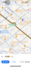
With the temporary closing of the D subte, I am taking the bus more often in Buenos Aires. One thing I have noticed is that sometimes the buses do not run along the same path that is indicated when I use Moovit, Google Maps, or the Transit app. For example, each of those shows the 111 bus will leave from the intersection of Bonpland and Soler and travel on Avenida Santa Fe to the corner of Avenida Coronel Diaz, in front of Alto Palermo. But one day, when I got on the 111 bus, it instead went down Paraguay and never got to Santa Fe. I had to take a long walk in hot weather to get to my destination. When attempting another ride today, the bus driver told me that the 111 doesn't go to Alto Palermo. Today I had a similar issue leaving on the 39c from the stop on Costa Rica at Plaza Unidad Latinoamericano to go to the intersection of Gorriti and Humbolt, where I wanted to get off. The maps show the bus traveling along Costa Rica before turning on Godoy Cruz and then Gorriti. But much of the trip actually was on Honduras, parallel to Costa Rico. Luckily, the bus eventually turned off Honduras onto Costa Rica, but still didn't follow the map. The blue dot on the attached map shows where the bus actually was, while the brown line shows the stated route.
Do the buses routinely ignore those mapped routes? Or are the apps that show the routes not accurate? In any case, how does one really know how to get somewhere on a collectivo?
Do the buses routinely ignore those mapped routes? Or are the apps that show the routes not accurate? In any case, how does one really know how to get somewhere on a collectivo?

